Uvero Alto: the northern end of the Punta Cana coast, and what that actually buys you
Where Uvero Alto is, and how far out it really sits
Uvero Alto is the last named stretch of the Punta Cana corridor as you travel north-west up the east coast. Arena Gorda, then Macao, then Uvero Alto: it sits beyond the dense resort strip rather than inside it, and that single fact explains most of what people notice when they get there.
The clearest way to feel the distance is the airport ladder. One long-running Punta Cana travel resource publishes transfer times for every area in the corridor, and read in order they say more than any description: Cap Cana at 5 to 8 miles and 10 to 15 minutes, Bávaro Beach at 10 to 14 miles and 20 to 25 minutes, Arena Gorda at 15 to 17 miles and 25 to 30 minutes, Macao Beach at 22 miles and 35 minutes, and Uvero Alto at 24 to 28 miles and 40 to 50 minutes. Uvero Alto is the far end of that list, and it is a long area in itself — the first hotel you reach is quicker than the last one.
Administratively it is not a town of its own. It is one of the communities of the El Salado section, inside the Verón–Punta Cana tourist municipal district, which is itself part of the municipality of Higüey in the province of La Altagracia. The district was created by Ley 386-06 of 3 October 2006, and El Salado also takes in Bávaro, Cortecito, Cabeza de Toro, Arena Gorda and Macao — so Uvero Alto shares a local government with the strip it feels so distant from.
The name is worth a sentence, because travel pages routinely get it wrong. An uvero is not a palm. It is the Dominican and wider Caribbean name for Coccoloba uvifera, the sea grape: a broad-leaved, salt-tolerant tree of the Polygonaceae that grows on open beach sand all over the region, holding the dune together with round leathery leaves and hanging bunches of fruit. Whether the settlement took its name from the tree is not something any authority we could find actually states, so this page will not claim it did.
The coastline: more golden, more open, and far emptier
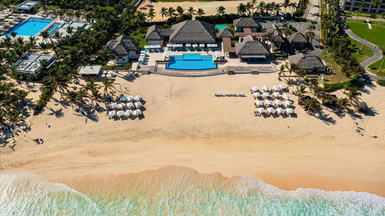
The sand at Uvero Alto reads differently from the postcard end of the corridor. The same travel resource that publishes the transfer table describes it as more golden than the bright white further south, with water that is less turquoise and a sea that can run rougher on some days. What it gains in exchange is space: these are markedly less frequented beaches, and on a long walk you will pass fewer people in an hour than you would pass in a minute at El Cortecito.
That emptiness is structural rather than seasonal. There are only a handful of hotels along this shore and they are set well apart, so there is no continuous wall of loungers and no procession of boat traffic. The same source lists no beach club here at all, and notes there is very little to eat directly on the sand — a real difference from a serviced beach, and the thing most day visitors underestimate. Public transport reaches the area only awkwardly, so in practice people arrive by taxi or rental car.
What the area is genuinely known for is horses. A few working ranches sit behind the shore and riding on the beach is the activity visitors associate with Uvero Alto more than any other. That is the texture of the place: ranch land and open sand rather than vendors and excursion buggies.
None of this makes it better or worse than the busier stretches, and it is worth resisting pages that tell you it does. It makes it different, in a way that suits some visitors exactly and frustrates others by lunchtime. If your idea of a beach day involves walking a long way and meeting nobody, this is the right end of the coast. If it involves a bar, a menu and a rented paddleboard within sight of your towel, it is the wrong one.
Uvero Alto against Bávaro and Cap Cana
These three names get used as if they were interchangeable parts of one destination, and they are not. They sit at different distances, they were built at different times and they behave differently on an ordinary Tuesday.
Cap Cana is the closest to the airport on the published ladder, at 5 to 8 miles and 10 to 15 minutes, and it is a planned gated enclave rather than a stretch of coast with things on it. Bávaro is the middle of the corridor at 10 to 14 miles and 20 to 25 minutes — the longest, densest and most walkable resort frontage, with the most shops, the most restaurants and by some margin the most people. Uvero Alto is the far end at 24 to 28 miles and 40 to 50 minutes, with the fewest hotels spread over the most sand.
The honest trade is a straight one: every mile north buys you quiet and costs you convenience. At the Bávaro end you can walk out of a lobby into a commercial street. At the Uvero Alto end an errand is a drive, and the return leg from the airport at the end of a long flight is the part people forget to price in. Neither is a defect. It is simply that a 40-to-50-minute transfer twice a holiday is a fair price for an empty beach, and an unfair one if you are going to spend your week wanting a pharmacy.
For a visitor that is a booking decision. For someone thinking about property it is a slower question, because the transfer you do twice a year as a guest is the one a renter does too, and it shows up in how a unit is chosen on a booking site. Location on this coast is not a matter of taste alone.
Sargassum at Uvero Alto: the honest answer
Seaweed is the first thing anyone asks about this coast and the place where marketing copy is least reliable, so it is worth being plain. Sargassum is an Atlantic phenomenon that drifts onto the eastern shore of the island in volumes that vary from year to year, and no page — this one included — can tell you what a particular week will look like.
For Uvero Alto specifically, the Punta Cana travel resource that tracks the coast week by week calls it the hardest area of the whole corridor to predict: one week can be nearly clear and the next can see a heavy influx. Its overall reading is that Uvero Alto is usually more affected than most beaches in the corridor, though less so than Playa Juanillo and Playa Blanca at the southern end. That is one observer's assessment rather than an agency measurement, and it is offered here as a tendency, not a forecast.
Two practical consequences follow. First, if a clear sea on a named date is the point of the trip, no stretch of this coast can promise it and you should plan around the possibility rather than against it — the heaviest part of a sargassum year is generally the early summer months. Second, if you are looking at property rather than a holiday, the relevant question is not whether weed arrives but what happens when it does: who clears it, how quickly, and whether the beach you will actually use is maintained by somebody or left to the tide. That answer differs enormously between a serviced beach and an open one, and it is worth asking out loud before it matters.
Who governs Uvero Alto — and why a buyer should care
This is the section most area guides skip, and it is the one that affects an owner rather than a guest.
Uvero Alto has no municipality of its own. It sits in the El Salado section of the Verón–Punta Cana tourist municipal district, created by Ley 386-06 of 3 October 2006, inside the municipality of Higüey in La Altagracia. A bill to raise that district to a full municipality — naming Uvero Alto among the communities it would take in — passed the Senate in 2025 and then lapsed in the National Congress; deputies revived the discussion publicly in September 2026. As of the date on this page it is not law, and nobody should write or read it as though the municipality already exists.
What has changed in practice is planning authority. The district now manages and charges for land use itself, on the basis of article 24 of Ley 368-22 on territorial planning, land use and human settlements, which means a building project in its territory starts with a land-use consultation at the district council rather than ending with one. That is general procedure and not advice on any parcel; a specific project belongs with an attorney and with the council.
The shoreline itself is public, and that is not a technicality here. Under Ley 305 of 1968 the maritime strip — roughly the first 200 feet inland from the high-tide line — is public property, inalienable and not for sale. The state enforces it on this exact coast: on 25 March 2025 the Ministry of Environment and Natural Resources, with the national environmental protection service SENPA, demolished restaurant and craft-shop structures standing inside that strip at playa Palmera in Uvero Alto, saying the operators held no environmental permits and had been notified in 2024.
Read that the right way round. It is not a warning that the beach is closed — it is not — and one operation is not a description of how the whole coast is policed. It is a demonstration that the public strip is real, that structures built into it are removable, and that anyone buying near a shoreline here should understand exactly where their title stops.
If you are buying on this coast, where the 8.9 miles matter
Poseidonia is not in Uvero Alto, and this page has no interest in blurring that. It is a community of 1,319 residences inside gated Cana Bay, priced from $179,000, with 20+ pools across the site, 371 residences currently available and delivery projected for 2028. Its own published drive times are about 5 minutes to the beach, about 25 to Punta Cana International Airport and about 17 to downtown. Uvero Alto lies roughly 8.9 miles away, measured as a straight line from this property's coordinates to the ones published for the locality — not a routed drive, and not a figure to convert into minutes, because nobody publishes that journey.
So why does an area guide to somewhere else belong on this site? Because the two places answer the same question differently, and a buyer who has only been shown one of them is choosing blind. Uvero Alto offers emptiness at the cost of distance. The middle of the corridor offers proximity at the cost of quiet. What matters is which cost you will actually be paying, week after week, for years.
The practical version is simple enough. If you will use the place yourself a few times a year and the drive is part of the holiday, distance is cheap and quiet is worth a great deal. If the property will spend most of its life being let, the airport transfer is somebody else's decision and it is made on a booking page, where 40 to 50 minutes reads differently from 25. And if you want both, you are looking for the point on this coast where the beach is still serviced and the traffic has already thinned — which is a judgement about a specific address, not about an area.
Drive it. The whole corridor is an hour from end to end and the ladder above is the itinerary. An afternoon spent going from Cap Cana to Uvero Alto and back will settle the question better than any page, including this one.
Common questions
- Where exactly is Uvero Alto?
- At the northern end of the Punta Cana corridor on the east coast of the Dominican Republic, beyond Arena Gorda and Macao. It is not a town in its own right: it is one of the communities of the El Salado section, within the Verón–Punta Cana tourist municipal district created by Ley 386-06 of 3 October 2006, inside the municipality of Higüey in La Altagracia province.
- How far is Uvero Alto from Punta Cana airport?
- One long-running Punta Cana travel resource publishes the transfer as 24 to 28 miles and 40 to 50 minutes, the far end of its list for the corridor — against 20 to 25 minutes for Bávaro Beach and 10 to 15 for Cap Cana. Uvero Alto is a long area, so the first hotel you reach is quicker than the last. Treat it as a published range rather than a fixed journey time.
- Is the beach at Uvero Alto better than Bávaro?
- It is different, and nothing ranks them. The sand is described as more golden and the water as less turquoise than further south, with a sea that can run rougher on some days, but the beaches are far less frequented and run to around 6 miles end to end. There is very little to eat on the sand and no beach club listed there, so the quiet costs you services. Bávaro is the opposite trade.
- Does Uvero Alto get seaweed?
- Sometimes, and it is the hardest stretch of this coast to predict — the resource that tracks sargassum here reports that one week can be nearly clear and the next heavily affected. Its overall reading is that Uvero Alto is usually more affected than most beaches in the corridor, though less so than Playa Juanillo and Playa Blanca. That is an estimate, not a measurement, and no page can tell you what a given week will bring.
- Is Poseidonia in Uvero Alto?
- No. Poseidonia is at Cana Bay, about 8.9 miles down the coast in a straight line, with published drive times of about 5 minutes to the beach, about 25 to the airport and about 17 to downtown. Uvero Alto is covered here because it is the alternative many buyers on this coast are weighing, not because it is where this development stands.
Want the details for your own situation?
Ask about availability, layouts or the buying process, and someone from the sales team will get back to you.
Get in touch